Introduction: DAMO Academy has released the AI Earth earth science cloud platform, which will be open to researchers free of charge to help earth science research on the cloud.
We are no strangers to remote sensing satellites. Each remote sensing satellite is the eyes of human beings placed in low-Earth orbit and outer space. They help us observe the earth accurately, diligently and tirelessly.
However, the data collected by the satellite will not be presented as simply and plainly as 1+1=2. To translate the satellite remote sensing data into effective information that we can use, according to the traditional method, it is generally divided into three steps:
- Apply to satellite data operating agencies to obtain data, or download industry public data;
- The data is stored and configured on the local computer;
- Local data processing, analysis and research.
The analysis process requires very high computing and storage resources of the machine, and ordinary computers are difficult to analyze large-scale image data. On the other hand, for the analysis of massive satellite remote sensing data, the traditional methods have not been able to solve the problems of low degree of automation, high cost and low interpretation efficiency.
The DAMO Academy AI Earth earth science cloud platform, a comprehensive functional platform to solve the above problems, came into being.
Based on the technical accumulation of DAMO Academy in the fields of deep learning, computer vision, and geospatial analysis, combined with the powerful computing power of Alibaba Cloud, the AI Earth earth science cloud platform provides cloud computing analysis of multi-source earth observation data such as remote sensing and meteorology. Services, use data to perceive the earth's world, and let AI help scientific research.
If you have the following usage requirements:
Individual users need to easily obtain massive amounts of public remote sensing data, and perform efficient cloud processing and analysis.
Government and enterprise users need to verify remote sensing AI capabilities based on their own business scenarios and build offline proprietary cloud systems.
Welcome to experience the AI Earth earth science cloud platform. At present, the platform supports online retrieval of various public data, online analysis of remote sensing images and related data management functions.
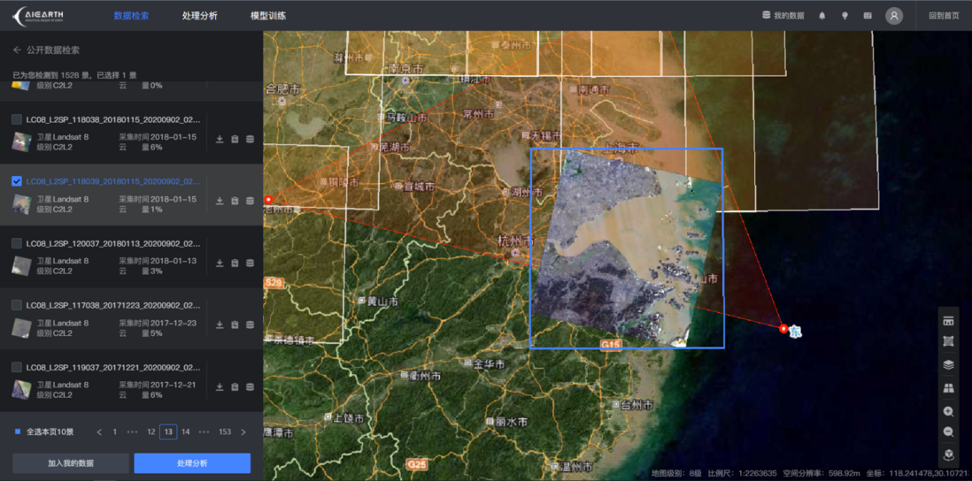
Multi-source data retrieval
At present, the platform has launched public datasets such as Landsat 5, Landsa 7, Landsa 8, Landsa 9, Sentinel-1, Sentinel-2, MODIS, etc. More thematic data are being updated. For detailed data specifications, please refer to the data set introduction page.
The platform supports four ways to determine the retrieval area: 1. Retrieval through POI information; 2. Retrieval through administrative divisions; 3. Retrieval by encircling the area on the map; 4. Retrieval by uploading vector files containing geographic information. After determining the scope of the retrieval area, continue to filter the data collection time, data type, cloud cover and other information, and click the retrieval button to get the required data list.
online data processing
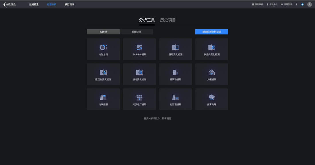
The platform takes advantage of DAMO Academy's remote sensing AI capabilities. For high-scoring data, it supports a variety of remote sensing AI online interpretation tools such as land object classification, change detection, building extraction, and plot extraction. For radar data such as Sentinel-1, the platform is online SAR data AI water body extraction function.
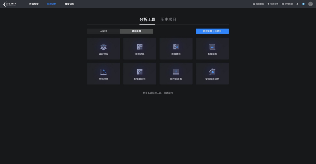
In addition, the platform also provides eight types of general-purpose raster and vector basic processing tools, including index calculation, mosaic clipping, band fusion, coordinate transformation, grid resampling, patch optimization, and time series diagram production, and more remote sensing data processing atoms. Capabilities are continuing to move to the cloud.
Cloud GIS Workspace
Based on the working perspective of GIS professional software, the platform presents various remote sensing data in the form of layer overlay, and categorizes various remote sensing data processing operators through the toolbox mode to realize convenient and efficient online processing of raster and vector data.
For the data processing process, the platform currently adopts the GUI operation link with no code and low threshold. Later versions are planned to support the developer mode based on JavaScript and Python to meet the needs of more developers and users.
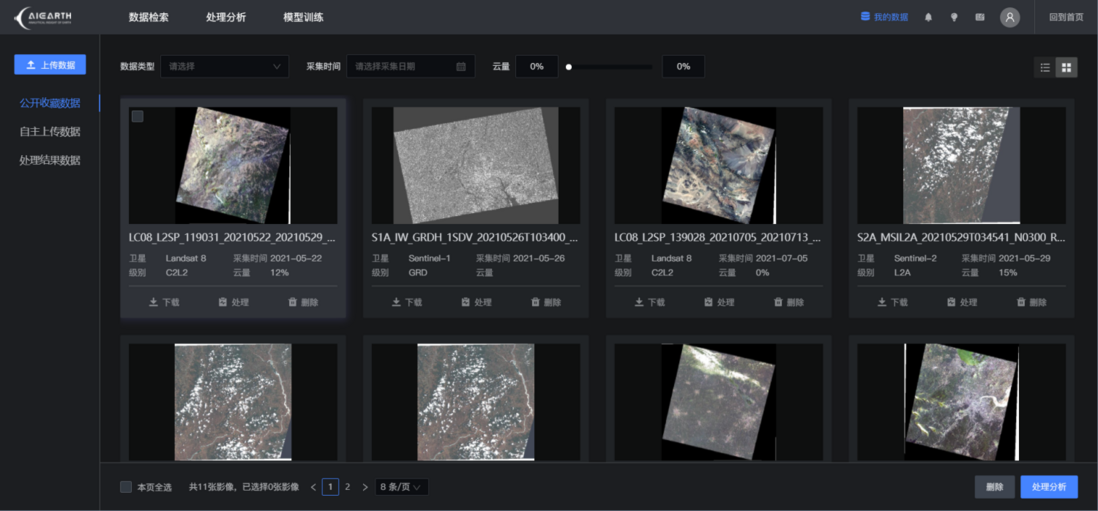
Multi-source data management
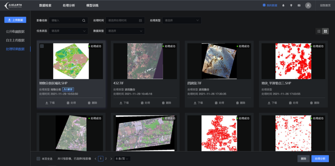
The platform supports users to manage online collected public data, self-uploaded high-score data, and result data analyzed and processed by the platform.
In the near future, the platform will continue to improve the atomic capabilities of public data sets and data processing, and support users to complete various remote sensing data analysis and processing work on the cloud, eliminating the tedious links for searching and downloading various raw data, and the data results can be directly applied or downloaded in the cloud. to the local.
model training
The platform supports user online model training, model management, sample labeling, and sample library management.
At the end of the year and the beginning of the year, Dharma Academy released the top ten technology trends in 2022. AI Earth is the first of the ten trends - an example application of AI for Science.
For thousands of years, experimental science and theoretical science have been the two basic paradigms in the scientific community. "People" discover scientific laws and then apply them; "people" then summarize scientific laws from a large amount of experimental data.
Today, artificial intelligence is giving birth to a new scientific research paradigm, and AI can autonomously discover scientific laws. In other words, it is AI that discovers new laws from a large amount of data, and then gives them to humans to use.
The open earth science cloud platform not only brings about a significant improvement in efficiency, but also frees researchers from complicated data acquisition and analysis steps; more technological, efficient, and convenient AI is accompanying humans to detect the mother planet Earth. in-depth knowledge.
AI Earth Earth Science Cloud Platform ( https://engine-aiearth.aliyun.com )
Copyright statement: The content of this article is contributed by Alibaba Cloud's real-name registered users. The copyright belongs to the original author. The Alibaba Cloud developer community does not own the copyright and does not assume the corresponding legal responsibility. For specific rules, please refer to the "Alibaba Cloud Developer Community User Service Agreement" and "Alibaba Cloud Developer Community Intellectual Property Protection Guidelines". If you find any content suspected of plagiarism in this community, fill out the infringement complaint form to report it. Once verified, this community will delete the allegedly infringing content immediately.






**粗体** _斜体_ [链接](http://example.com) `代码` - 列表 > 引用。你还可以使用@来通知其他用户。