
foreword
Start with travel and integrate into life. The proposal of the "dual carbon" strategic goal has created new opportunities for the construction of smart cities. Smart transportation, as the backbone transportation mode for cities to guide and carry low-carbon travel, has become an important goal of promoting high-quality urban development in various regions in the current era.
With the continuous improvement of urban rail transit operation level and the rapid expansion of operation scale, the construction of smart urban rail can be described as a representative field of "new infrastructure". In-depth integration of various link systems and multi-type services of urban rail transit with spatial perception, mobile internet, cloud computing and other technologies, to centrally realize the digital presentation of urban space, urban rail distribution, and urban rail operation dynamics, and finally complete real-life dynamic monitoring and perception , command and dispatch, event linkage and other functions to create a data governance system for the whole life cycle.
Show results
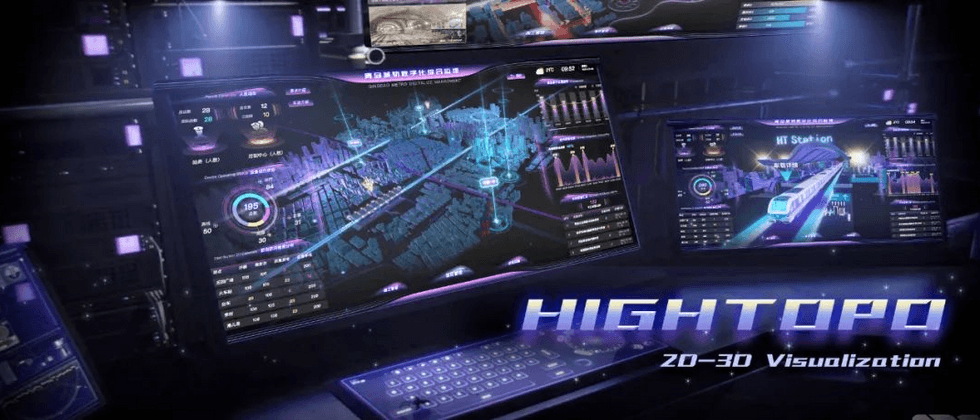
Tupu software applies self-developed HT products, seamlessly integrates 2D and 3D visualization technologies, and builds a set of lightweight Qingdao urban rail digital comprehensive operation and maintenance solutions. The initial interface takes the three-dimensional map of China as the background and Qingdao as the base point. The overall urban rail network layout of the city is highlighted from a macro perspective, and then drills down to each station to check the operation status of the corresponding station. The scene is overly smooth and particularly natural.
The three-dimensional visual monitoring mechanism of smart urban rail covers the entire business process of urban rail planning, construction, operation and maintenance. The refined management model solves the current problems in equipment maintenance, personnel scheduling, passenger service and emergency command, and accelerates the global perception, control, analysis and sharing of urban rail service levels, production efficiency, and operational safety data. , to create a smart operation center for users to perceive the city's situation on one screen.
System analysis
wire mesh visualization
Hightopo uses HT for Web GIS products to build a real-life twin base for rail transit, and one map presents key rail transit data within the required range. The eye-catching highlight streamer effect is selected to focus on the key transportation hubs, and comprehensively display the physical location distribution and real-time status information of each station, typhoon and flood prevention points, duty points, and material and spare parts points.

By superimposing the rich visual charts and animation effects of Tupu software by sensing components, the dynamic operation parameters such as key personnel, equipment, emergency events, early warning and alarms in each line are collected, and displayed in the 2D configuration panels on both sides, which is the urban rail line network. Provides concise and clear data explanation for multi-dimensional operation and maintenance requirements.

The positioning of the HT for Web GIS product is to use its powerful visualization technology to present the data of the Geographic Information System (GIS) in a rich visualization form. Supports the loading of different map tile services or data, 3DTiles format data of aerial oblique photography real scenes, and different GIS data such as urban building groups. It can accurately synchronize with the 3D scene, which not only retains the effects and functions of the GIS engine, but also does not limit the designer's play in the 3D scene.
Aerial view of the city
Qingdao is located at the southern end of the Shandong Peninsula, with the urban scenery of "red tiles, green trees, blue sea and blue sky"; beautiful and magnificent seaside scenery; typical European-style multinational buildings, and the integration of mountains, seas and cities makes Qingdao a pearl on the coast of the Yellow Sea. .
Attractions
Click the button of Qingdao North Station to drill down to the city scene, and Tupu software will digitally twin Qingdao city based on the city's CAD map, bird's eye view, equipment three views and other data, and restore major scenic spots with high-precision modeling.

city roaming
It supports space roaming for each scenic spot, and the route will display the relevant information of each scenic spot, and browse every corner of the city in 360° omnidirectional without dead ends, bringing users a strong and realistic sensory impact. The HT engine of Tupu software realizes interactive web 3D scenes. You can rotate, pan, and zoom the scene through the mouse. It also supports one-finger rotation, two-finger zooming, and three-finger translation of touch screen devices.
It can customize urban plots, buildings, environments, etc. in science fiction, realism or more styles according to user needs to help improve the overall external image.

Passenger flow information
Visualization uses advanced target detection, recognition, and tracking technology to calculate and track characteristic indicators such as crowd density, temperature of people entering and leaving, and contraband, and monitor the safety and flow of people in public places. Scientifically predict the peak time period of passengers, assist managers in allocating on-duty personnel in a balanced manner, and improve the service quality of the station and the travel experience of passengers.
It integrates information, technology, equipment and traffic supervision systems organically, and integrates multi-source and heterogeneous data by configuring all-round situations such as urban ground, vehicle details, rail operations, and passenger flow operations. Covering business areas such as overall urban rail situation monitoring, population distribution analysis, and hub situation monitoring, building a comprehensive interconnection of elements such as people, machines, objects, and states, effectively improving the efficiency of cross-departmental decision-making and resource coordination.

Urban Rail Roaming Inspection
In the past, the deployment of traditional urban rail equipment was scattered, resource information was independent, business efficiency was low, and the 2D-based monitoring interface was no longer suitable for the complex application scenarios of modern urban rail.
Station equipment visualization
Hightopo 3D intelligent inspection scene, which dynamically renders and reproduces key equipment such as human body temperature measurement, explosion detection, liquid detection, X-ray machine, gate, elevator and other key equipment in the station hall, and deeply integrates power, environment, access control, and power quality. and other monitoring systems, link the background to access real data, and perceive the information attributes of equipment and assets through the 3D view, such as clicking on the equipment model to query the fault, location, status and other data information of a single equipment.
The roaming inspection function selects the first-person perspective for full-time automatic inspection according to the added multi-type inspection content and multiple inspection paths. Meet the operation and maintenance management characteristics of different types of assets to ensure that asset information is evidence-based.

Train roaming inspection
Based on multi-dimensional parameters such as time, space, and quality, dynamic monitoring of physical systems such as train environment, automatic control, and power supply system automation is deployed. When an alarm event such as a smoke detector, camera, screen door or abnormal personnel behavior is identified, the system immediately initiates a positioning diagnosis on the warning location, and informs the relevant personnel to take command and control such as passenger flow evacuation, fire linkage, and emergency dispatch.
You can also manually select each facility on the train to view the equipment number, name, location and other information, and monitor and manage the real-time images in the train compartment. Realize two-way communication between drivers and station duty personnel, control center dispatchers, and depot staff. Create a closed loop of data monitoring for asset management, condition monitoring, risk warning, and fault diagnosis.

Visualization of train running situation
The HT engine of Tupu software supports seamless integration of various multimedia functions of HTML5, links various security subsystems, and conducts dynamic security monitoring for the entire train. Equipped with a new generation of vehicle-ground communication, Beidou navigation and positioning system, environmental perception and 5G communication technology, the track and tunnel status are uploaded synchronously, providing refined, high-frequency and detailed data support for the operation situation and geographic trajectory of trains entering and leaving the station. Strengthen the train's ability to perceive the traveling space and on-board space information.

The advantages of Tupu software's B/S architecture can satisfy users to use PC, PAD or smart phone anytime and anywhere, and access the demand interface through the browser to realize remote monitoring and control.
Intelligent early warning
In order to follow the development principle of "safe and reliable, demand-oriented, economical and reasonable" for smart stations. Based on multiple dimensions such as space, time, and indicators, build various types of focus event threshold alarm triggering rules. When the performance threshold is exceeded, the management personnel are notified of the problem location by positioning and flashing, and the 2D configuration panel pop-up window displays the cause of the failure. . Operation and maintenance personnel can formulate a feasible equipment maintenance plan based on multi-level analysis such as generation of historical retrospective comparison, operation report, and optimization plan.

The cluttered data is simplified and refined, and combined with professional data models and analysis algorithms in the transportation field for real-time analysis and judgment, it helps to obtain higher value of the data, so as to strengthen the monitoring breadth and depth of equipment operation status, and improve the daily assets in the station. Maintenance efficiency, fully realize the purpose of preventing micro-duplication.
construction management
Smart construction conducts real-time perception monitoring for the elements of "people, machines, materials, methods, and environment" on the construction site. In order to ensure the standardization of the urban rail construction process, Tupu software uses 2D and 3D visualization engine, GIS, video fusion and other technologies to combine key factors such as construction production, quality, and safety to create a digital platform for thorough perception, data sharing, and interconnection and collaboration.

Diversified charts, graphics and design elements of Tupu are used to interpret data in different dimensions on attendance statistics, project progress, construction distribution, equipment station operation, and construction costs. Rational integration of the construction site and surrounding conditions from multiple perspectives helps users easily trace the output ratio of the production process, avoiding unnecessary on-site check-ins or waste of labor materials.

Compared with the traditional two-dimensional configuration monitoring system, the three-dimensional configuration monitoring scene is more intuitive, simple and efficient, and it is convenient to quickly identify abnormal information. The video can also be seamlessly embedded into the scene through the emerging video fusion technology to truly restore the scene.
By connecting intelligent sensors, it can remotely monitor the operation of on-site tower cranes, elevators, excavators and other operating equipment, and display the construction effect and construction status of the equipment in 3D. Breaking the operation form of traditional manual monitoring, realize the three transparency of environment, data and behavior in the construction process, and meet the supervision mode of flattening, gridding and greening of business links.

Combined with BIM 3D modeling, Tupu software can realize the dynamic rehearsal of the whole process of coordination before, during and after construction, such as obtaining the surface, space size, foundation, backfilling, etc. It not only forms a clear sectional view of the dense line network pipes, but also displays the construction objects in a three-dimensional form. It overcomes the problem that traditional plane drawings cannot be laid intuitively, greatly improves construction efficiency and reduces construction losses. The lightweight method of Tupu software HT has made a new change in the traditional BIM technology:
 * HT 具有轻量化、低成本的优点,企业无需再购置笨重昂贵的 BIM 软件;
* 起点低、效果好,传统 Web 开发人员也可轻松上手,借力 HT 强大的 3D 渲染效果即可做出高仿真施工场景。
emergency
As a highly perfect emergency plan for public emergencies, Hightopo supports the establishment of an emergency management and control system for public emergencies oriented to facility linkage, operation structure, and passenger management. When identifying an emergency incident of carrying dangerous goods or disaster prevention and rescue, the system quickly locates the accident site, links the source of danger, hidden danger, and accident data, and releases emergency information, broadcast, and PIS linkage broadcast according to the risk level, and assists in planning the evacuation of passengers from the station. . Provide monitoring plans, emergency plan steps, information release or restoration and reconstruction and other related content to facilitate users to track, promote, and feedback incident handling in a timely manner.

It supports the integration of information, events, and linkage resources according to the evolution law of events and the comprehensive situation of urban rail coupling risks, operational safety pressure, and social coverage, and classifying them according to the emergency plan process. One-click command and dispatch of firefighting, public security, medical care, etc. Linked deployment of various resources. Open up cross-industry, cross-department, and cross-level collaborative dispatch and command to achieve the purpose of "one picture" audible, visual, and interactive visual command.
Summarize
The smart urban rail visualization solution realizes various functions such as data fusion, data display, and data monitoring by virtue of advanced human-computer interaction methods. It can be widely used in the monitoring and management of light rail, subway, tram, maglev, monorail and other rail transit systems.
The digital transformation of rail transit is essentially a microcosm of the process of urban construction. In the whole set of solutions, Tupu software smart urban rail breaks through the information barriers between software and hardware. Through the integration of multiple sets of related business systems, massive, high-frequency, and refined data bases are collected, and under accurate data analysis, real-time data changes of passenger flow, trains, and stations are displayed, and the management of people, vehicles, and objects in the urban rail system is reshaped. The relationship between.
Form the application value sharing from the whole to the local, from the surface to the underground, from static to dynamic, from single system to multi-system, from indoor to outdoor. Provide data support for urban rail transit to accelerate green and low-carbon transformation, improve energy efficiency, and promote the urban rail industry to do a good job of "carbon peaking and carbon neutrality".
Tupu software is not only easy to use in the application of 3D configuration industry, but also its advanced configuration interface is very suitable for the interface presentation of real-time monitoring system.
Compared with the traditional configuration software of InTouch/IFix/WinCC, the web-based platform of Tupu is more suitable for the general trend of C/S to B/S transformation. The multi-element rich visualization components and fast data binding methods can be used for fast Create and deploy. Combined with VR/AR display, users can be immersed in the virtual environment for experience. Build modern enterprise applications across desktops and mobile terminals without worrying about cross-platform compatibility and touch screen gesture interaction.
For more industry application examples, please refer to the case link on the official website of Tupu Software: https://www.hightopo.com/demos/index.html


**粗体** _斜体_ [链接](http://example.com) `代码` - 列表 > 引用。你还可以使用@来通知其他用户。